 Dr. Jeffrey T. Freymueller
Precise GPS Geodetic measurements have been made in the Nepal Himalaya and Tibetan Plateau since March 1991. GPS field campaigns were carried out in Nepal in March-April 1991, October 1992, and November 1995. GPS campaigns in Tibet were carried out in March-April 1991 and October-November 1995. Significant additional work has been carried out by Chinese workers, including the Xi'an College of Geology, Wuhan Technical University of Surveying and Mapping, and the State Seismological Bureau, Wuhan.
This page summarizes the major work done over the last two years both at the University of Colorado and the Geophysical Institute, with emphasis given to the activities carried out at the Geophysical Institute, University of Alaska, Fairbanks.
Photo: Freysteinn Sigmundsson

Title: Displacement and Strain Rates in the Indian/Eurasian Collision Zone
NSF EAR95-21922 .
In November 1995, we conducted a successful GPS field campaign in Tibet, repeating GPS measurements made by Dr. Roger Bilham of the University of Colorado in 1991. Simultaneous measurements were made at 22 sites in Nepal and India by Roger Bilham, and at sites around the eastern and northern borders of Tibet by Dr. Liu Benpei of the Wuhan Technical University of Surveying and Mapping. Our Tibet measurements were made in collaboration with Dr. Wang Wenying of the Xi'an College of Geology. In addition, Bilham doubled the number of measurement points in W. Nepal in a collaborative survey with two French Groups (Avouac and LeFort), and doubled the number of measurement points in E. Nepal by observing gravity and GPS at the locations of the 1950 triangulation survey of Mt. Everest (Gulatee, 1952). Despite the logistical and political difficulties involved in working in Tibet, we were able to collect more data than we initially planned to acquire. The data from this survey have been analyzed, giving a typical baseline precision of 2-4 mm in the horizontal components and 6-10 mm in the vertical. We have estimated site velocities for only two of the five Tibetan sites so far due to some difficulties with part of the 1991 data (we expect to solve this problem by this spring at the latest), and for all of the Nepalese sites which have been measured multiple times.
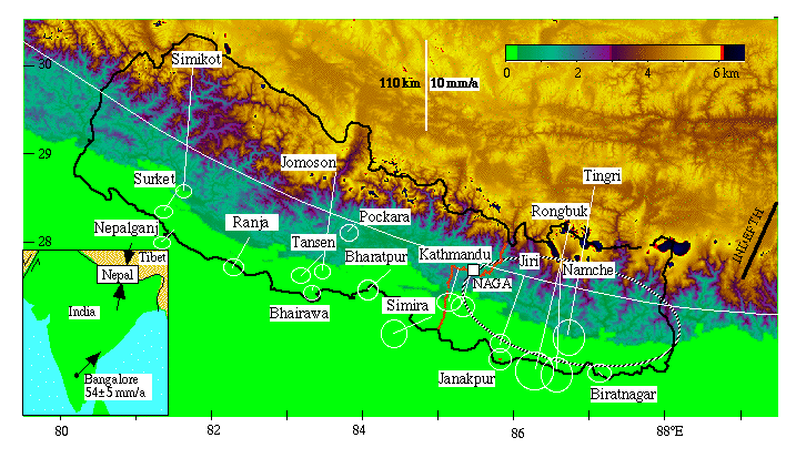
Velocity vectors and associated uncertainties near Nepal are shown in Figure 1 (Bilham et al., 1996). The mean India-Tibet convergence vector is directed N 5° E with an inferred subsurface slip rate of India beneath Tibet of 20±3 mm/year. More details of the interpretation of the convergence process are presented in the body of this proposal. The motion of India relative to Asia (ITRF92 reference frame) is 54±4 mm/year at N 45±5° E, confirming that the Indian plate is rotating slowly counterclockwise relative to the Australian plate (Freymueller et al., 1996).

Figure: Velocities based on 1991-1995 Global Positioning System (GPS) measurements for 18 sites in Nepal and southern Tibet (Bilham et al., Nature in press). Velocities are shown relative to Bangalore (S. India). The white curved line indicates a smoothed small circle that approximates the Himalayan arc and follows a line of river incision and moderate earthquakes defined by Seeber and Gornitz (1983). The approximate location of the 1934 Bihar/Nepal earthquake is shown by a large ellipse in E. Nepal. Inset: ITRF92 Indian Plate vector and mean convergence direction between India and Tibet (Freymueller et al., 1996).
Permanent GPS sites have been installed in Bangalore (originally installed by Bilham, now operated by JPL), Nagarkot (30 km east of Kathmandu), and at New Banewswor near the center of subsidence in the Kathmandu Valley. As this proposal is being written, Bilham is installing 6 additional fixed GPS sites in Nepal and two in India (at Leh in Kashmir, and Almora in Kumaon).
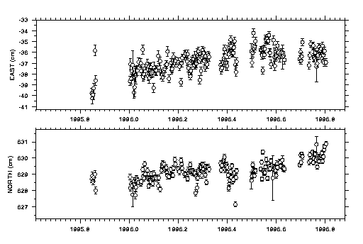
This grant to the Geophysical Institute has supported daily analysis of a regional network covering the India-Eurasia plate boundary zone. The daily solutions begin on January 1, 1996. We use orbits from the International GPS Service (IGS) and data from about 20 stations surrounding the India-Tibet area. We have made a specific effort to include all data from continuous sites in the region, even those whose data are available only after a significant time delay. For example, for much of 1996, the data from the Lhasa were available only 1-2 months after collection due to a failure of communications equipment. The cleaned data from our daily analysis is also being used by Kristine Larson at the University of Colorado to analyze permanent station data from Nepal. Figure 2 shows the daily time series for Lhasa relative to Kitab, Uzbekistan, showing the northward and eastward translation of Tibet. Based on 9 months of continuous measurements and a few global solutions from October 1995, Lhasa moves east 26 mm/yr. and north 15 mm/yr. relative to Kitab, which is located on the Eurasian plate (nominal uncertainties are 3 mm/yr. east, 1 mm/yr. north, based on the rms scatter about the best fit line). Due to the short time span of our observations, these velocities are very sensitive to small changes in the solutions to an extent much greater than would be predicted based on the nominal velocity uncertainties. As a result, the uncertainties may be over-optimistic. The eastward motion of Lhasa is 13 mm/yr. more rapid than would be predicted if Lhasa lay on the Indian plate. The northward motion of Lhasa appears consistent with the 20±3 mm/yr. slip rate derived for the Nepal Himalaya.

Figure: Horizontal motion of Lhasa relative to Kitab (Uzbekistan, on the Eurasian plate) based on daily solutions for the first nine months of 1996 plus six solutions from November 1995. The rms scatter of the daily estimates about the best-fit line is 8 mm in the east component and 4 mm in the north component of this 2438 km long baseline, giving velocity uncertainties of 3 mm/yr. east and 1 mm/yr. North. The zero point on the vertical axes is arbitrary.
The velocity of Lhasa appears to be significantly different than the velocities of both Tingri and Rongbuk about 500 km to the west, with Lhasa moving eastward by about 15 mm/yr. relative to Tingri and Rongbuk. We should be able to confirm these results soon, once enough data from our other Tibetan sites closer to Lhasa are analyzed. Our tentative interpretation is that extension within Tibet is more rapid than previously predicted; other explanations are possible and will be explored during the next two years. We need both a longer time series for Lhasa to be certain of the reliability of the velocity estimate, and more data from sites nearby to constrain possible tectonic models.
We have made arrangements to host a visiting scientist from the Institute of Seismology, State Seismological Bureau (SSB) who will bring and analyze all of the GPS data collected by Chinese agencies in and around the Tibetan plateau. Wang Qi from SSB will visit Fairbanks for three months in the summer of 1997 and all remaining data from 1991-1995 will be analyzed during that visit, including the remaining 1991 data which did not make it out of China (one site) or has not yet been possible to read (two sites). We also have established a strong collaborative relationship with the Xi'an College of Geology and we plan to host a visiting scientist from Xi'an within the next two years.
Publications Resulting From This Work:
Bilham, R., K. Larson, J. Freymueller, and Project Idyllhim members, Indo-Asian Convergence Rates in the Nepal Himalaya, accepted for publication in Nature, 1996.
Freymueller, J., R. Bilham, R. Burgmann, K.M. Larson, J. Paul, S. Jade,
and v. Gaur, Global Positioning measurements of Indian Plate Motion and
Convergence across the Lesser Himalaya, Geophys. Res. Lett., 23,
3107-3110, 1996.